|
Virginia Tech Earthquake Engineering Center aims to prepare Southeast for likely seismic events by Liz Crumbley
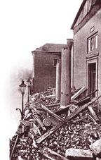
The most damaging seismic event in the United States before the 1906 earthquake that destroyed San Francisco occurred on the East Coast. The Charleston, S.C. earthquake of 1886, which damaged buildings as far away as Richmond and Atlanta, reached an estimated magnitude of 7.3 on the Richter scale--essentially the same magnitude as the shock that killed more than 17,000 people in northwestern Turkey last August. Another ominous similarity exists. "In terms of seismic vulnerability, many buildings in the southeastern U.S. today are similar to those in Turkey," says James Martin, an associate professor of civil and environmental engineering who went to Turkey to study the effects of that earthquake. "In neither place is there adequate structural protection of buildings. If another 7.3 magnitude earthquake hit Charleston today, the city would suffer much the same damage as cities in Turkey." The South Carolina coast is not the Southeast's only area vulnerable to earthquakes. In 1897, an earthquake with an estimated magnitude of 6.0 rocked Virginia Tech--the shock was centered in neighboring Giles County and was felt from Pennsylvania to Georgia. And, although we tend to think of Alaska and California as the typical sites of seismic activity in the U.S., eastern Tennessee is one of the most active areas in the nation in terms of the number of earthquakes recorded. Despite the Southeast's potential for major earthquakes in the future, few engineering studies or emergency response plans have been devised. That's why professors Martin and Martin Chapman, director of the Virginia Tech Seismological Observatory, have founded the Earthquake Engineering Center for the Southeastern U.S. (ECSUS). "The southern Appalachian highlands have the potential for even larger earthquakes than have occurred in the past," Martin says. "But now those 'quakes would take place in much more highly populated areas. "'Felt' earthquakes don't occur as often in the Southeast as in California because the tectonic strain rates are different," he says. "We tend to experience large earthquakes isolated by long periods of quiet. "However," Martin warns, "we are under a significant threat of large, damaging earthquakes." The Southeast lies in the middle of the North American plate, while the large faults in California, such as the San Andreas fault, are on the boundary between the North American and Pacific plates. A plate is a vast, mobile block of the earth's crust, and plates move against one Nevertheless, Charleston, Richmond, and parts of the Tennessee Valley have the potential to experience major shocks, Chapman says. "Geologial history shows that, during the past 4,000 to 5,000 years, the region has experienced about six earthquakes large enough to liquefy the ground," he says. (During a major earthquake, the water pressure in low, sandy soils may increase to a level at which the earth actually becomes liquid and buildings topple.) Earthquakes of the same magnitude of those in California pack more punch in the Southeast. "The earth's crust is stronger here," Chapman says. "So shock waves moving from the epicenter of an earthquake don't lose as much energy as during quakes in California. When a magnitude 7 earthquake occurs in the Southeast, the waves affect a larger area and can cause more damage at a greater distance than when a similar shock hits California." Martin, Chapman, and other ECSUS researchers seek to reduce the vulnerability of the Southeast to severe earthquake damage by developing and disseminating critical seismic data and technology. Funding for the ECSUS already has been provided by the U.S. Geological Survey and more is expected from Virginia Tech, the South Carolina Department of Transportation, other government agencies, and private companies. Updating seismic hazard maps and earthquake detection and mitigation technology is a major goal for the ECSUS. "Very little research on seismic hazard mapping has been conducted specific to the Southeast," Martin says. Most of the latest maps for the region have been developed from Virginia Tech's catalog of historical and seismic instrumentation data, and the university's monitoring network is key to future ECSUS work. Maps need to be created that show regional hazards, especially those in urban areas, he notes. Currently, Chapman says, hazard maps available in the Southeast are national maps last updated by the USGS in 1996. These maps offer a good national perspective but don't provide detailed data for specific sites. The ECSUS will develop localized hazard maps and teach the region's engineers to use them. Charleston will be the subject of the first series of maps, developed with the latest Geographical Information System (GIS) technology. These computer-based maps will show site-specific potentials for earthquakes that can help engineers and architects determine if a structure is being designed in an earthquake-prone area and can help local planners develop protective building codes. GIS technology also will be crucial after an earthquake occurs. "When an earthquake triggers seismic monitors," Martin explains, "the information is fed to a GIS network. Within minutes, a local emergency response team can see where the worst damage likely occurred so that teams can be dispatched immediately to the areas most in need of help." The ECSUS will manage the transfer of such data and technology to the Southeast. For example, Martin says, engineers who are building a bridge in an earthquake-prone area of South Carolina need to use the latest seismic engineering technology and building code criteria, developed primarily in the western U.S. ECSUS will aid in that information exchange and help adapt the technology to the Southeast. Building codes are another priority for ECSUS. Codes in the eastern U.S. have been updated to reflect information from 1996 earthquake hazard maps and recent findings on soil response to strong motion. An organized effort needs to be underway to inform the engineering community in the Southeast about important new design procedures. "We want the ECSUS to serve as a regional voice," Martin remarks. "The Southeast needs experts who can address methods of updating building codes and structural designs specific to the needs of the region. We also want to promote the continued evolution of building codes." "The ECSUS will provide a service that engineers, architects, emergency response teams, and the public in the Southeast needa central clearinghouse for critical earthquake information," Chapman says. "It's important that people not become alarmed at the prospect of earthquakes in our region, but we need to learn how to be prepared." Liz Crumbley is public information coordinator for the College of Engineering. Home | News | Features | Philanthropy | Alumni | Classnotes | Editor's Page
|
 another, causing the tectonic strains (forces that affect the earth's crust) that result in earthquakes. The Southeast has less frequent major earthquakes because of its location in the middle of a plate.